Right now, the geology on my mind is the geology of the northern flank of the Apennine Mountains in Italy. From April 30 to May 12, I will be joining a team of structural geologists, tectonicists, sedimentologists, and paleomagnetists to study Plio-Pleistocene sedimentation along the north flank of the tectonically-active Apennine Mountains, in and around the spa town of Salsomaggiore Terme (salty thermal springs). The project is evaluating possible links among tectonics, sedimentation, and climate in the development of mountain belts. I hope to blog from the field, although I may be limited by how often I have access to the Internet.
A lot of what we will be doing is detailed sampling of Plio-Pleistocene sediments in river banks, collecting mud that is just barely lithified, for paleomagnetic analysis to establish a detailed mangento-stratigraphy. Once a chronology can be established, then depositional rates can be determined and compared to the tectonic and climatic history of the area. It's a different kind of field work from anything I have ever done before and I am really looking forward to it.
My role, beyond providing labor in the field, is to use the work of the project to create classroom materials for earth science teachers. I will be looking for ways in which the data sets we generate can drive useful inquiry by students at a variety of levels. I hope to create materials that are specifically connected to existing inquiry-based earth science curricula (EarthComm and Investigating Earth Systems), but will be useful to teachers of any curriculum. If you have any comments about what would make such materials most useful, please share them.
Tuesday, April 28, 2009
Wednesday, April 22, 2009
There's a volcano in my kitchen (or classroom, or...)
 There's a volcano in my kitchen almost every night. That's where I sit to use my laptop.
I have been tracking Redoubt volcano in Alaska for the past several months. The Alaska Volcano Observatory as been using a Twitter feed (@avo_alaska) and their web site to share information on the increasing activity, and then eruption, of the volcano. Of course, there is news coverage anytime a volcano erupts near a populated area, but this one is different because of both the amount of information available and the ease with which it can be acquired. The picture at right is from the Hut webcam, one of three regularly updated images of the volcano available at the AVO website. The combination of the Twitter feed and webcam feeds provide an almost real-time stream of information, both text and images, from the volcano and have made it possible to have a much more personal experience of this eruption than for previous eruptions, accessible only through the media's coverage. In addition, the technology available is improving very rapidly.
Recently, AVO installed a new webcam at their Hut site - this cam is now zoomed in on the crater, showing the lava dome you can see in the image above. The camera's resolution is high enough to see the geometry of cracks in the surface of the growing lava dome and sensitive enough to detect incandescence in the dome at night. That's amazing! I can probably see more detail at my kitchen counter than I could if I were standing at the Hut station myself, unless I had a zoom lens or binoculars with me there.
I've taken courses on volcanology in graduate school and read professional papers on volcanoes, but I have still learned a tremendous amount about the evolution of a lava dome and especially about the time scales of activity from this day-by-day experience. I've also learned a bunch about related topics, such as the weather in southern Alaska (it's cloudy more than it's clear at Redoubt this time of year and there are frequent snowfalls).
Now consider the image below:
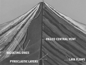 This is the image that most students get of this type of volcano. This one is from a USGS
online book about volcanoes, but there is little difference between this image and most earth science textbooks. There are things in this image that cannot be seen in the picture that led off this post, so it is important to have students see this sort of image. The trouble is that there is nothing about this image that grabs you. There is no immediacy and no reality. It is clearly a cartoon.
The active photo, especially when it changes from minute to minute, hour to hour, and day to day, has an immediacy and reality that this does not. It also has detail that this does not. The real-life picture shows the gasses being vented and even a thin gray smear of ash coming off the middle of the dome in front of all that condensed steam. It clearly shows that there are no lava flows associated with this event, but that there is a debris apron around the dome and also that there is an impact on hydrology (water in the stream draining from below the dome.) None of this is in the textbook picture. The real world picture is much more complex than the pre-digested textbook picture. That means it is harder to interpret, but it also makes it a much richer springboard for inquiry.
Dan Meyer has inspired me with his "What can you do with this?" sequence on the use of real-life images and video to teach mathematics. It also ties into a question I learned from a talk by Don Duggan-Haas at GSA - "Why does this place look this way?" I would love to see more science teachers using this kind of real world data to promote student engagement and student inquiry. So let me pose that question to you readers - what can you do with the image at the top of this page? Also, do you have images that you think are good prompts for open-ended exploration, measurement, or other forms of inquiry? Please share in the comments.
PS: Here's another AVO image: http://www.avo.alaska.edu/image.php?id=18224 This one has a scale in it and shows the prominent waterfall in the gorge below the dome (altough the scale only roughly applies to the dome, due to the horizontal separtion of the dome from the falls). Interestingly, that "little" waterfall is roughly twice the height of Niagara Falls!
Tuesday, April 21, 2009
Wildflysch?
Even though my favorite geoblog name was already taken (Highly Allochthonous), I have decided it is time to join the geoblogosphere. Wildflysch was the next most appropriate name I could come up with.
Wildflysch is a term coined by Franz Josef Kaufmann, a Swiss geologist, in 1871 to describe rocks with a strong and often folded foliation in a slate or schist matrix surrounding blocks of varying size and rock type. The term is used mostly in European geology and has been largely supplanted by the concept of a melange, recognized as a tectonic assemblage rather than a stratigraphic unit. These chaotic assemblages are generally thought to form in subduction zones, but have also been interpreted as the result of gravity-driven slumping.
The idea of chaotic assemblage under high pressures seemed like it might be an apt analogy for the way this blg is likely to come together, given the other commitments I have. This blog will also likely end up containing a mix of "blocks" on varied topics in geology and earth science education, extending, or perhaps straining, the anlaogy. As often as not, it will contain musings about questions rather than answers, but that is the nature of science and scientists.
I feel profoundly lucky that I have been able to make my love of the natural world and my love of teaching into work that I deeply enjoy and am passionate about. I look forward to sharing some of that with whoever happens by and finds this and I look forward to hearing your comments in response, whether you are pleased, provoked, or foliated.
Subscribe to:
Comments (Atom)