What he said! (just substitute science or math for marketing)
You might want to check out some of Seth Godin's other posts. After all, creating motivation is an everyday part of what marketers do. You might also want to check out his TED talk. What could you do in a classroom with his ideas about tribes and leadership?
Sunday, June 14, 2009
Monday, May 18, 2009
Miocene to Recent sediments of the northern Apennines
The materials we were studying in the Northern Apennines were very young sediments (geologically speaking, at least, where 1 million years is not much time at all). Below is a series of photos and descriptions that attempt to lay out the sequence of these rocks in the way they would be seen in a geologic column, youngest on top.
 At the top of the section are the very recent Quaternary terraces, Qt8 and Qt9. These are 50-year old floodplain deposits that have been incised by downcutting related to gravel mining that began shortly after WWII.
Each of the surfaces separating these units in an unconformity (time passed without deposition of sediment). The lower boundary of Qt8 in this picture is an excellent example of an angular unconformity.

Here we see Qt3 on top of Qt2. The top of Qt2 has a deeply weathered "fossil" soil or paleosol. The presence of carbonate nodules in that soil indicate a prolonged period of warm and dry climate. The lower gravel (Qt2) was deposited about 450,000 years ago and the soil developed about 400,000 years ago
 Here is Qt2 on top of Qt1. Qt1 is the oldest Quaternary gravel stream terrace in the region. It is moderately tilted everywhere along the mountain front and is characterized by a reddish weathering soil at its top. This soil developed about 630,000 years ago
 This is the upper mud in the AEI (Association Emilliano Inferiore - Lower Emillia Association). The AEI consists of alternating lake muds, representing glacial periods, gravels, representing glacial melting, and soils developed on top of the gravels, representing interglacial times. These sediment cycles occur due to 100,000 year cycles in the eccentricity of Earth's orbit. The reddish strata in the background are debris flow gravels that lie on top of this mud.

Here is another mud interval (yellow and grey material at the bottom of the photo), overlain by a thin fluvial gravel and then by debris flows. This is the second of three such cycles in AEI.

Here is a fossil cypress(?) stump at the top of the lowermost AEI mud unit This shows the unit was deposited on land,or in very shallow water
 This is the lowest unit in AEI. This mud contains terrestrial fossils and was deposited in a lake on land. The base of this mud is roughly 800,000 years old.
Somewhere in the AEI unit, should be the most recent magnetic reversal in Earth's history. At this time, the magnetic field went from a period of reversed polarity (Matuyama chron) to a period of normal polarity (Brunhes chron). The Brunhes-Matuyama reversal occurred 780,000 years ago.

These interbedded sands and gravels lie at the very top of the Sabbie Gialle.
This unit is approximately 1 million to 800,000 years old

The muds of the Argille Azzure are overlain by medium to thick bedded sands and gravels of the Sabbie D'Imola (Sand of Imola), locally known as the Sabbie Gialle (Yellow Sand)

In the upper part of the Argille Azzure, fossils are abundant. In particular, there are beds of very coarse calcarenite (calcite sands) made of shells and shell fragments. These beds range from 3.1 Ma (million years ago) to 1.8 Ma, corresponding to the Gelasiano and Piacenzian Ages of the middle Pliocene Epoch.

These grey muds of the Argille Azzure show distinct bedding. Much of the Argille Azzure is completely homogeneous mud with no evident bedding. The differences between the bedded and unbedded parts may reflect differences in the depositional environment, in the sediment supply, r in the degree of bioturbation (churning of the sediment by living creatures). The Argille Azzure was deposited between approximately 4.9 and 1 Ma (million years ago).

Cross-bedded sandstones of the upper Miocene Colobacci Formation. This formation is 5.6-5.3 Ma in age. There is an unconformity (time without deposition) between the Colombacci and the overlying Argille Azzure.

Beneath the Colombacci is a very unique rock unit, formed roughy 6 million years ago. These are the Messinian evaporites. This picture shows bedded gypsum that grew out of the evaporating waters of the Mediterranean Sea. Above these rocks lie layers of gysum crystal conglomerates (resedimented gypsum).

Here is a detailed view of the gypsum crystals that make up the Messinian evaporites in this section.
 At the top of the section are the very recent Quaternary terraces, Qt8 and Qt9. These are 50-year old floodplain deposits that have been incised by downcutting related to gravel mining that began shortly after WWII.
Each of the surfaces separating these units in an unconformity (time passed without deposition of sediment). The lower boundary of Qt8 in this picture is an excellent example of an angular unconformity.

Here we see Qt3 on top of Qt2. The top of Qt2 has a deeply weathered "fossil" soil or paleosol. The presence of carbonate nodules in that soil indicate a prolonged period of warm and dry climate. The lower gravel (Qt2) was deposited about 450,000 years ago and the soil developed about 400,000 years ago
 Here is Qt2 on top of Qt1. Qt1 is the oldest Quaternary gravel stream terrace in the region. It is moderately tilted everywhere along the mountain front and is characterized by a reddish weathering soil at its top. This soil developed about 630,000 years ago
 This is the upper mud in the AEI (Association Emilliano Inferiore - Lower Emillia Association). The AEI consists of alternating lake muds, representing glacial periods, gravels, representing glacial melting, and soils developed on top of the gravels, representing interglacial times. These sediment cycles occur due to 100,000 year cycles in the eccentricity of Earth's orbit. The reddish strata in the background are debris flow gravels that lie on top of this mud.
Here is another mud interval (yellow and grey material at the bottom of the photo), overlain by a thin fluvial gravel and then by debris flows. This is the second of three such cycles in AEI.

Here is a fossil cypress(?) stump at the top of the lowermost AEI mud unit This shows the unit was deposited on land,or in very shallow water
 This is the lowest unit in AEI. This mud contains terrestrial fossils and was deposited in a lake on land. The base of this mud is roughly 800,000 years old.
Somewhere in the AEI unit, should be the most recent magnetic reversal in Earth's history. At this time, the magnetic field went from a period of reversed polarity (Matuyama chron) to a period of normal polarity (Brunhes chron). The Brunhes-Matuyama reversal occurred 780,000 years ago.

These interbedded sands and gravels lie at the very top of the Sabbie Gialle.
This unit is approximately 1 million to 800,000 years old

The muds of the Argille Azzure are overlain by medium to thick bedded sands and gravels of the Sabbie D'Imola (Sand of Imola), locally known as the Sabbie Gialle (Yellow Sand)

In the upper part of the Argille Azzure, fossils are abundant. In particular, there are beds of very coarse calcarenite (calcite sands) made of shells and shell fragments. These beds range from 3.1 Ma (million years ago) to 1.8 Ma, corresponding to the Gelasiano and Piacenzian Ages of the middle Pliocene Epoch.

These grey muds of the Argille Azzure show distinct bedding. Much of the Argille Azzure is completely homogeneous mud with no evident bedding. The differences between the bedded and unbedded parts may reflect differences in the depositional environment, in the sediment supply, r in the degree of bioturbation (churning of the sediment by living creatures). The Argille Azzure was deposited between approximately 4.9 and 1 Ma (million years ago).

Cross-bedded sandstones of the upper Miocene Colobacci Formation. This formation is 5.6-5.3 Ma in age. There is an unconformity (time without deposition) between the Colombacci and the overlying Argille Azzure.

Beneath the Colombacci is a very unique rock unit, formed roughy 6 million years ago. These are the Messinian evaporites. This picture shows bedded gypsum that grew out of the evaporating waters of the Mediterranean Sea. Above these rocks lie layers of gysum crystal conglomerates (resedimented gypsum).

Here is a detailed view of the gypsum crystals that make up the Messinian evaporites in this section.
Friday, May 15, 2009
Catching up after Italy

Well, I didn't get nearly as much blogging done in Italy as I might have hoped. Two big reasons - one is that we spent most of our waking hours as you see on the left, up to our knees in Torrente Stirone.

The other, as you see in the second picture, is that our apartment was a bit remote and had no Internet access of any sort.
So now, I'm back and I'm finally caught up with what was waiting on my desk, so I can get a few updates posted on my time in Italy.
We had a great time. The grad student, whose project this is, Kellen, three faculty working with him, and I all had a chance to work together and we got a lot done. The primary work involved measuring the stratigraphic section and sampling for magnetic intensity and for magnetic reversals. For magnetic intensity, we took bulk samples of the sediment every 0.75 meters or 1 meter of section. Because the rocks were tilted, this corresponded to about 2 to 2.5 meters along the river bank. We needed a way to mark the sample sites and the normal method of using a dot of spray paint was not going to work on these soft and wet muds.
On our very first day, inspiration hit when we stopped for gelato on our way home. The little plastic gelato spoons were brightly colored, had a flat area where we could write a number, and a relatively stiff stem that could be pushed into the mud. Our one Italian speaker asked the proprietor if we could buy some and he responded "This is not a spoon store." We persevered and the next morning, we were able to buy a big bag of gelato spoons from the owner. Here is one of those spoons marking a sample site.

After all the samples had been collected, we removed the spoons. Here's is the first day's take.

When I left Italy, we had collected over 500 of these samples. They will be analyzed for their magnetite content to test the hypothesis that there will be a periodicity to the magnetic intensity that matches the 100,000 year and 400,000 years cycles of eccentricity in Earth's orbit around the sun. These cycles are paralleled by climate cycles, making the magnetic intensity measurements a proxy for climate and allowing the project to evaluate possible links between climate cyclicity and patterns in deformation, if there are any. As this data comes in, I will be working to figure out how students can engage with this data set to understand more about basic concepts in earth science, but first we wait and hope that all those boxes yield something useful.
Coming up next: 6 million years of mountain building and climate, recorded in sediments.
Friday, May 8, 2009
Little Boxes on the Hillside... (or at least on the riverbank
The free Internet at the local library won't talk to Blogger, so it's time for a cell phone update. We have been busy collecting samples of mud for the magnetic study. Every two meters along the bank, we stuff a 2 cm plastic cube with sediment, mostly mud. The boxes have been pre-weighed and numbered, so we have to keep track of which is which and where they get filled. Today, we collected oriented samples to look for magnetic reversals. In order to preserve the orientation while getting it into the box, we had to carve little pedestals of mud and slip the boxes over them, then measure the orientation of the box before cutting the box off of the outcrop, trimming off the excess, and putting on the lid. 9 boxes took 6 hours.
Tomorrow is a field trip then one more day in the river before heading home.
Monday, May 4, 2009
Day 3 in the field: we have measured and sampled more than 60 meters of sand and mud, sampling every .75 m. The rocks are Miocene and Pliocene and are barely lithified. They look like rocks, but you sink in to your ankles when you step in a wet spot. We've also seen a whole set of Quaternary gravel terraces, some of which are tilted by deformation.
More details on Thursday!
Tuesday, April 28, 2009
Getting ready for Italy
Right now, the geology on my mind is the geology of the northern flank of the Apennine Mountains in Italy. From April 30 to May 12, I will be joining a team of structural geologists, tectonicists, sedimentologists, and paleomagnetists to study Plio-Pleistocene sedimentation along the north flank of the tectonically-active Apennine Mountains, in and around the spa town of Salsomaggiore Terme (salty thermal springs). The project is evaluating possible links among tectonics, sedimentation, and climate in the development of mountain belts. I hope to blog from the field, although I may be limited by how often I have access to the Internet.
A lot of what we will be doing is detailed sampling of Plio-Pleistocene sediments in river banks, collecting mud that is just barely lithified, for paleomagnetic analysis to establish a detailed mangento-stratigraphy. Once a chronology can be established, then depositional rates can be determined and compared to the tectonic and climatic history of the area. It's a different kind of field work from anything I have ever done before and I am really looking forward to it.
My role, beyond providing labor in the field, is to use the work of the project to create classroom materials for earth science teachers. I will be looking for ways in which the data sets we generate can drive useful inquiry by students at a variety of levels. I hope to create materials that are specifically connected to existing inquiry-based earth science curricula (EarthComm and Investigating Earth Systems), but will be useful to teachers of any curriculum. If you have any comments about what would make such materials most useful, please share them.
Wednesday, April 22, 2009
There's a volcano in my kitchen (or classroom, or...)
 There's a volcano in my kitchen almost every night. That's where I sit to use my laptop.
I have been tracking Redoubt volcano in Alaska for the past several months. The Alaska Volcano Observatory as been using a Twitter feed (@avo_alaska) and their web site to share information on the increasing activity, and then eruption, of the volcano. Of course, there is news coverage anytime a volcano erupts near a populated area, but this one is different because of both the amount of information available and the ease with which it can be acquired. The picture at right is from the Hut webcam, one of three regularly updated images of the volcano available at the AVO website. The combination of the Twitter feed and webcam feeds provide an almost real-time stream of information, both text and images, from the volcano and have made it possible to have a much more personal experience of this eruption than for previous eruptions, accessible only through the media's coverage. In addition, the technology available is improving very rapidly.
Recently, AVO installed a new webcam at their Hut site - this cam is now zoomed in on the crater, showing the lava dome you can see in the image above. The camera's resolution is high enough to see the geometry of cracks in the surface of the growing lava dome and sensitive enough to detect incandescence in the dome at night. That's amazing! I can probably see more detail at my kitchen counter than I could if I were standing at the Hut station myself, unless I had a zoom lens or binoculars with me there.
I've taken courses on volcanology in graduate school and read professional papers on volcanoes, but I have still learned a tremendous amount about the evolution of a lava dome and especially about the time scales of activity from this day-by-day experience. I've also learned a bunch about related topics, such as the weather in southern Alaska (it's cloudy more than it's clear at Redoubt this time of year and there are frequent snowfalls).
Now consider the image below:
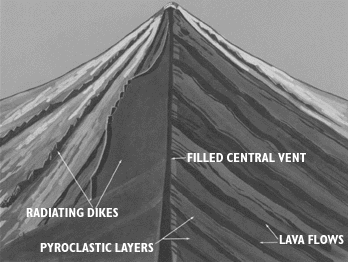 This is the image that most students get of this type of volcano. This one is from a USGS
online book about volcanoes, but there is little difference between this image and most earth science textbooks. There are things in this image that cannot be seen in the picture that led off this post, so it is important to have students see this sort of image. The trouble is that there is nothing about this image that grabs you. There is no immediacy and no reality. It is clearly a cartoon.
The active photo, especially when it changes from minute to minute, hour to hour, and day to day, has an immediacy and reality that this does not. It also has detail that this does not. The real-life picture shows the gasses being vented and even a thin gray smear of ash coming off the middle of the dome in front of all that condensed steam. It clearly shows that there are no lava flows associated with this event, but that there is a debris apron around the dome and also that there is an impact on hydrology (water in the stream draining from below the dome.) None of this is in the textbook picture. The real world picture is much more complex than the pre-digested textbook picture. That means it is harder to interpret, but it also makes it a much richer springboard for inquiry.
Dan Meyer has inspired me with his "What can you do with this?" sequence on the use of real-life images and video to teach mathematics. It also ties into a question I learned from a talk by Don Duggan-Haas at GSA - "Why does this place look this way?" I would love to see more science teachers using this kind of real world data to promote student engagement and student inquiry. So let me pose that question to you readers - what can you do with the image at the top of this page? Also, do you have images that you think are good prompts for open-ended exploration, measurement, or other forms of inquiry? Please share in the comments.
PS: Here's another AVO image: http://www.avo.alaska.edu/image.php?id=18224 This one has a scale in it and shows the prominent waterfall in the gorge below the dome (altough the scale only roughly applies to the dome, due to the horizontal separtion of the dome from the falls). Interestingly, that "little" waterfall is roughly twice the height of Niagara Falls!
Tuesday, April 21, 2009
Wildflysch?
Even though my favorite geoblog name was already taken (Highly Allochthonous), I have decided it is time to join the geoblogosphere. Wildflysch was the next most appropriate name I could come up with.
Wildflysch is a term coined by Franz Josef Kaufmann, a Swiss geologist, in 1871 to describe rocks with a strong and often folded foliation in a slate or schist matrix surrounding blocks of varying size and rock type. The term is used mostly in European geology and has been largely supplanted by the concept of a melange, recognized as a tectonic assemblage rather than a stratigraphic unit. These chaotic assemblages are generally thought to form in subduction zones, but have also been interpreted as the result of gravity-driven slumping.
The idea of chaotic assemblage under high pressures seemed like it might be an apt analogy for the way this blg is likely to come together, given the other commitments I have. This blog will also likely end up containing a mix of "blocks" on varied topics in geology and earth science education, extending, or perhaps straining, the anlaogy. As often as not, it will contain musings about questions rather than answers, but that is the nature of science and scientists.
I feel profoundly lucky that I have been able to make my love of the natural world and my love of teaching into work that I deeply enjoy and am passionate about. I look forward to sharing some of that with whoever happens by and finds this and I look forward to hearing your comments in response, whether you are pleased, provoked, or foliated.
Subscribe to:
Comments (Atom)